


2016 07 Colombieres-sur-Orb - gorges - sommet caroux - Roc Mato Capel

vertygo
User
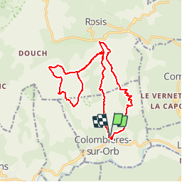

Length
18.3 km

Max alt
1090 m

Uphill gradient
1070 m
Km-Effort
33 km

Min alt
218 m

Downhill gradient
1083 m
Boucle
Yes
Creation date :
2017-04-04 00:00:00.0
Updated on :
2017-04-04 00:00:00.0
6h36
Difficulty : Difficult

FREE GPS app for hiking
 SityTrail
IGN / Geographical institutes
SityTrail Plus
The world is yours!
About
Trail Walking of 18.3 km to be discovered at Occitania, Hérault, Colombières-sur-Orb. This trail is proposed by vertygo.
Positioning
Country:
France
Region :
Occitania
Department/Province :
Hérault
Municipality :
Colombières-sur-Orb
Location:
Unknown
Start:(Dec)
Start:(UTM)
500922 ; 4825444 (31T) N.
Comments