


Causse-de-la-Selle - Mas Gervais - Rocs des Aucelous

vertygo
User
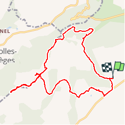

Length
11.2 km

Max alt
555 m

Uphill gradient
351 m
Km-Effort
15.9 km

Min alt
277 m

Downhill gradient
353 m
Boucle
Yes
Creation date :
2017-03-21 00:00:00.0
Updated on :
2017-03-21 00:00:00.0
3h20
Difficulty : Medium

FREE GPS app for hiking
 SityTrail
IGN / Geographical institutes
SityTrail Plus
The world is yours!
About
Trail Walking of 11.2 km to be discovered at Occitania, Hérault, Causse-de-la-Selle. This trail is proposed by vertygo.
Description
voir des photos sur www.vertygo.org
https://goo.gl/photos/NhuXywA6d79y8g767
Positioning
Country:
France
Region :
Occitania
Department/Province :
Hérault
Municipality :
Causse-de-la-Selle
Location:
Unknown
Start:(Dec)
Start:(UTM)
550527 ; 4849939 (31T) N.
Comments
Bonne rando
A faire