


Ravin des Arcs - Pont St Etienne d'Issensac

vertygo
User
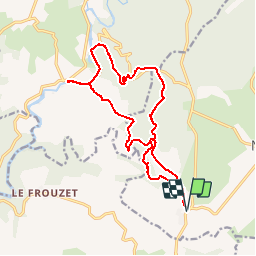

Length
17.2 km

Max alt
406 m

Uphill gradient
635 m
Km-Effort
26 km

Min alt
107 m

Downhill gradient
633 m
Boucle
Yes
Creation date :
2017-03-21 00:00:00.0
Updated on :
2017-03-21 00:00:00.0
5h25
Difficulty : Medium

FREE GPS app for hiking
 SityTrail
IGN / Geographical institutes
SityTrail Plus
The world is yours!
About
Trail Walking of 17.2 km to be discovered at Occitania, Hérault, Notre-Dame-de-Londres. This trail is proposed by vertygo.
Description
Voir des photos sur www.vertygo.org
https://goo.gl/photos/hAoYkGc9VhBnnVWF6
Positioning
Country:
France
Region :
Occitania
Department/Province :
Hérault
Municipality :
Notre-Dame-de-Londres
Location:
Unknown
Start:(Dec)
Start:(UTM)
559678 ; 4851260 (31T) N.
Comments