


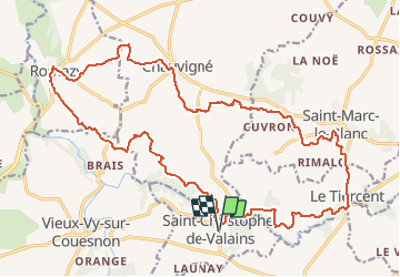
04.07.2016.De Romazy au Tiercent.Tracé virtuel (1)

babeth35
User

Length
24 km

Max alt
102 m

Uphill gradient
291 m
Km-Effort
28 km

Min alt
44 m

Downhill gradient
292 m
Boucle
Yes
Creation date :
2016-07-04 00:00:00.0
Updated on :
2020-07-20 15:32:06.643
6h01
Difficulty : Unknown

FREE GPS app for hiking
 SityTrail
IGN / Geographical institutes
SityTrail Plus
The world is yours!
About
Trail Walking of 24 km to be discovered at Brittany, Ille-et-Vilaine, Saint-Christophe-de-Valains. This trail is proposed by babeth35.
Positioning
Country:
France
Region :
Brittany
Department/Province :
Ille-et-Vilaine
Municipality :
Saint-Christophe-de-Valains
Location:
Unknown
Start:(Dec)
Start:(UTM)
615090 ; 5355555 (30U) N.
Comments