Trail Walking Stavelot - Water Trek - Le Parcours des Vallées - Etape 6 : Coo-Targnon - Photo

Water Trek - Le Parcours des Vallées - Etape 6 : Coo-Targnon

Randonnées d'Aqualis PRO

© OpenStreetMap contributors
Length
Length
18.3 km
Max alt
Max alt
503 m
Uphill gradient
Uphill gradient
584 m
Km-Effort
Km-Effort  
26 km
Min alt
Min alt
206 m
Downhill gradient
Downhill gradient
594 m
Boucle
Boucle
No
Signpost
Signpost
Creation date :
2018-04-09 13:01:23.567
Updated on :
2018-04-09 13:01:23.567

(0 Reviews)

Walking
Walking
5h40
Difficulty : Medium

Scan this QR Code to open this trail in the SityTrail application

FREE GPS app for hiking

Logo SityTrail SityTrail

IGN / Geographical institutes

Download SityTrail from the App Store Download SityTrail from Google Play

Logo SityTrail SityTrail World

The world is yours!

Download SityTrail from the App Store Download SityTrail from Google Play Download SityTrail on Huawei AppGallery

About

Trail Walking of 18.3 km to be discovered at Wallonia, Liège, Stavelot. This trail is proposed by Aqualis.

Description

Après un début en force, jusqu’au lac supérieur, la descente vers l’Amblève vous mènera jusqu’à un des hauts lieux de la bataille des Ardennes, le village de la Gleize, pour ensuite longer l’Amblève jusqu’à destination.

Elevation profile

Photos

Points of interest

Point of interest Stavelot - CAMPING DE LA CASCADE - Photo
Aqualis
Point of interest Stavelot - LAC INFERIEUR - Photo
Aqualis
STAVELOT 
Point of interest Stavelot - LA CASCADE DE COO - Photo
Aqualis
Point of interest Stavelot - PLOPSACOO - Photo
Aqualis
STAVELOT 
Point of interest Stavelot - RESTAURANTS - Photo
Aqualis
STAVELOT 
Point of interest Trois-Ponts - LAC SUPERIEUR - Photo
Aqualis
TROIS-PONTS 
Point of interest Stoumont - CHAR TIGRE - Photo
Aqualis
STOUMONT 
Point of interest Stoumont - musee DECEMBRE 44 - Photo
Aqualis
Point of interest Stoumont - EGLISE DE LA GLEIZE - Photo
Aqualis
Point of interest Stoumont - CHATEAU DE FROIDCOUR - Photo
Aqualis

Positioning

Country:
Belgium
Region :
Wallonia
Department/Province :
Liège
Municipality :
Stavelot
Location:
Stavelot
Start:(UTM)
704497 ; 5586348 (31U) N.

Trails nearby

Trail Walking Trois-Ponts - RB-Lg-29_Wanne - Photo
Walking
PRO

Walking

(5)
Trois-Ponts, Wallonia, Liège, Belgium
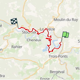
22 km | 29 km-effort
6h 41min
Yes
Trail Walking Trois-Ponts - RB-Lg-27_Trois-Ponts - Photo
Walking
PRO

Walking

(7)
Trois-Ponts, Wallonia, Liège, Belgium
23 km | 33 km-effort
7h 30min
Yes
Trail Walking Stoumont - RB-LG-13 - Par monts et par vaux autour de Stoumont - Photo
Walking
PRO

Walking

Very difficult
(11)
Stoumont, Wallonia, Liège, Belgium
23 km | 32 km-effort
7h 19min
Yes
Trail Walking Stavelot - 2021-06-30_12h14m27_stavelot_13km_new - Photo
Walking
GUIDE
mumu.larandonneuse

Walking

Medium
(2)
Stavelot, Wallonia, Liège, Belgium
13.4 km | 19.8 km-effort
4h 30min
Yes
Trail Walking Stoumont - IR-224 & RB-SoirMag-06_La-Glaise-_QR3_Rac1Rac2_13_9_km - Photo
Walking
PRO

Walking

Medium
(2)
Stoumont, Wallonia, Liège, Belgium
13.9 km | 19.8 km-effort
4h 30min
Yes
Trail Walking Stoumont - 2021-03-12_16h39m43_LaGleizeP3TourduMontSaintVictor - Photo
Walking
GUIDE
mumu.larandonneuse

Walking

Medium
(2)
Stoumont, Wallonia, Liège, Belgium
15.8 km | 22 km-effort
5h 2min
Yes
Trail Walking Stavelot - 2021-03-10_14h59m08_1227 - Photo
Walking
GUIDE
mumu.larandonneuse

Walking

Difficult
(3)
Stavelot, Wallonia, Liège, Belgium
18.8 km | 26 km-effort
5h 53min
No
Trail Walking Trois-Ponts - RB-Lg-27_Trois-Ponts_via-racc - Photo
Walking
PRO

Walking

Very difficult
(1)
Trois-Ponts, Wallonia, Liège, Belgium
16.9 km | 25 km-effort
5h 36min
Yes
Trail Walking Stavelot - Chemin des Sources |stage 3 STAVELOT - HOCKAI - Photo
Walking
PRO

Walking

Very difficult
(1)
Stavelot, Wallonia, Liège, Belgium
19 km | 25 km-effort
5h 45min
No


Close
My subscriptions