


MC4 Salers-Mendaille

azipat
User
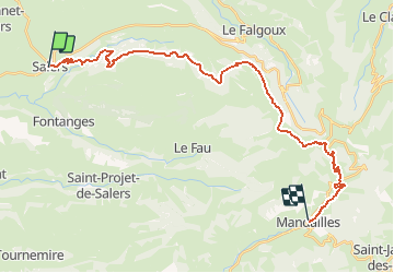

Length
29 km

Max alt
1633 m

Uphill gradient
1159 m
Km-Effort
44 km

Min alt
745 m

Downhill gradient
1187 m
Boucle
No
Creation date :
2016-07-10 00:00:00.0
Updated on :
2016-07-10 00:00:00.0
5h13
Difficulty : Medium

FREE GPS app for hiking
 SityTrail
IGN / Geographical institutes
SityTrail Plus
The world is yours!
About
Trail Equestrian of 29 km to be discovered at Auvergne-Rhône-Alpes, Cantal, Salers. This trail is proposed by azipat.
Positioning
Country:
France
Region :
Auvergne-Rhône-Alpes
Department/Province :
Cantal
Municipality :
Salers
Location:
Unknown
Start:(Dec)
Start:(UTM)
460217 ; 4998411 (31T) N.
Comments