


Saint jean d'alcas

nanie
User
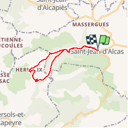

Length
11.5 km

Max alt
650 m

Uphill gradient
412 m
Km-Effort
17 km

Min alt
437 m

Downhill gradient
412 m
Boucle
Yes
Creation date :
2016-07-11 00:00:00.0
Updated on :
2016-07-11 00:00:00.0
3h34
Difficulty : Easy

FREE GPS app for hiking
 SityTrail
IGN / Geographical institutes
SityTrail Plus
The world is yours!
About
Trail Walking of 11.5 km to be discovered at Occitania, Aveyron, Saint-Jean-et-Saint-Paul. This trail is proposed by nanie.
Positioning
Country:
France
Region :
Occitania
Department/Province :
Aveyron
Municipality :
Saint-Jean-et-Saint-Paul
Location:
Unknown
Start:(Dec)
Start:(UTM)
500438 ; 4863876 (31T) N.
Comments