Trail Other activity Satolas-et-Bonce - Sato course a pied 11km - Photo
© OpenStreetMap contributors
Length
Length
10.9 km
Max alt
Max alt
257 m
Uphill gradient
Uphill gradient
92 m
Km-Effort
Km-Effort  
12.1 km
Min alt
Min alt
203 m
Downhill gradient
Downhill gradient
91 m
Boucle
Boucle
Yes
Creation date :
2016-07-13 00:00:00.0
Updated on :
2016-07-13 00:00:00.0

(0 Reviews)

Other activity
Other activity
1h06
Difficulty : Unknown

Scan this QR Code to open this trail in the SityTrail application

FREE GPS app for hiking

Logo SityTrail SityTrail

IGN / Geographical institutes

Download SityTrail from the App Store Download SityTrail from Google Play

Logo SityTrail SityTrail World

The world is yours!

Download SityTrail from the App Store Download SityTrail from Google Play Download SityTrail on Huawei AppGallery

About

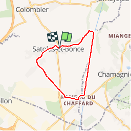
Trail Other activity of 10.9 km to be discovered at Auvergne-Rhône-Alpes, Isère, Satolas-et-Bonce. This trail is proposed by franckben.

Description

Tour sato par Village , BAs Bonce , Chaffard, Bourbre , La Chana

Elevation profile

Positioning

Country:
France
Region :
Auvergne-Rhône-Alpes
Department/Province :
Isère
Municipality :
Satolas-et-Bonce
Location:
Unknown
Start:(UTM)
665894 ; 5062123 (31T) N.

Trails nearby

Trail Mountain bike Chamagnieu - Rando des Etangs - Chamagnieu   - Photo
Mountain bike
tracegps

Mountain bike

Medium
Chamagnieu, Auvergne-Rhône-Alpes, Isère, France
26 km | 35 km-effort
2h 30min
Yes
Trail Mountain bike Chamagnieu - Autour de Chamagnieu - Photo
Mountain bike
tracegps

Mountain bike

Difficult
Chamagnieu, Auvergne-Rhône-Alpes, Isère, France
29 km | 36 km-effort
2h 30min
Yes
Trail Walking Chamagnieu - Autour de Chamagnieu - Photo
Walking
tracegps

Walking

Difficult
Chamagnieu, Auvergne-Rhône-Alpes, Isère, France
29 km | 36 km-effort
5h 30min
Yes
Trail Walking Satolas-et-Bonce - chauffard  - Photo
Walking
cricri34

Walking

Easy
Satolas-et-Bonce, Auvergne-Rhône-Alpes, Isère, France
3.9 km | 4.3 km-effort
57min
No
Trail Walking Tignieu-Jameyzieu - La Tignieulande - Photo
Walking
cricri34

Walking

Very easy
Tignieu-Jameyzieu, Auvergne-Rhône-Alpes, Isère, France
9.2 km | 10.2 km-effort
1h 57min
Yes
Trail Plane Colombier-Saugnieu - Barcelone - Photo
Plane
momogoofy

Plane

Very easy
Colombier-Saugnieu, Auvergne-Rhône-Alpes, Rhône, France
640 km | 821 km-effort
1h 5min
No
Trail Walking Chamagnieu - Autour de Mianges - Photo
Walking
Elaan4

Walking

Medium
Chamagnieu, Auvergne-Rhône-Alpes, Isère, France
9.1 km | 11.5 km-effort
2h 48min
No
Trail Walking Satolas-et-Bonce - Haut de Bonce 7.5 a  41 g0.5 d16- pk imp des Mûres - Photo
Walking
jtraverse

Walking

Very easy
Satolas-et-Bonce, Auvergne-Rhône-Alpes, Isère, France
7.5 km | 8.1 km-effort
2h 34min
Yes
Trail Walking Chamagnieu - SityTrail - Chamagnieu- Zglise 5.9 a 110 g 1 d23 - Photo
Walking
lydiaodile

Walking

Medium
Chamagnieu, Auvergne-Rhône-Alpes, Isère, France
5.9 km | 7.4 km-effort
1h 35min
Yes


Close
My subscriptions