


rando en gaume

julien707
User
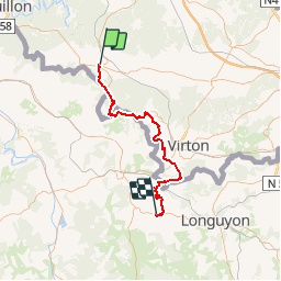

Length
55 km

Max alt
368 m

Uphill gradient
1119 m
Km-Effort
71 km

Min alt
187 m

Downhill gradient
1212 m
Boucle
No
Creation date :
2016-08-01 00:00:00.0
Updated on :
2016-08-01 00:00:00.0
15h03
Difficulty : Medium

FREE GPS app for hiking
 SityTrail
IGN / Geographical institutes
SityTrail Plus
The world is yours!
About
Trail Walking of 55 km to be discovered at Wallonia, Luxembourg, Florenville. This trail is proposed by julien707.


Positioning
Country:
Belgium
Region :
Wallonia
Department/Province :
Luxembourg
Municipality :
Florenville
Location:
Florenville
Start:(Dec)
Start:(UTM)
666708 ; 5507784 (31U) N.
Comments