


Chiaperra - Rocca Provenzale - Col Eighier

vertygo
User
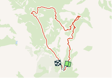

Length
11.5 km

Max alt
2550 m

Uphill gradient
897 m
Km-Effort
24 km

Min alt
1648 m

Downhill gradient
902 m
Boucle
Yes
Creation date :
2017-04-04 00:00:00.0
Updated on :
2017-04-04 00:00:00.0
4h51
Difficulty : Medium

FREE GPS app for hiking
 SityTrail
IGN / Geographical institutes
SityTrail Plus
The world is yours!
About
Trail Walking of 11.5 km to be discovered at Piemont, Cuneo, Acceglio. This trail is proposed by vertygo.
Description
voir des photos et d'autres randonnées sur www.vertygo.org
https://goo.gl/photos/BVZDUoU63fdWsnC68
Positioning
Country:
Italy
Region :
Piemont
Department/Province :
Cuneo
Municipality :
Acceglio
Location:
Unknown
Start:(Dec)
Start:(UTM)
334808 ; 4929263 (32T) N.
Comments