![](/images/other/stat-length.png)
![Trail Walking Boisset-lès-Montrond - Montrons les Bains - Photo](https://media.geolcdn.com/t/1900/400/ext.pjpeg?maxdim=2&url=https%3A%2F%2Fstatic1.geolcdn.com%2Fsiteimages%2Fupload%2Ffiles%2F1553511878bg_sport_marche.png)
Montrons les Bains
gannet1
User
![Length](/images/other/stat-length.png)
Length
11.5 km
![Max alt](https://static1.geolcdn.com/siteimages/upload/files/1508320355ic_sort_altitude_max_24dp.png)
Max alt
359 m
![Uphill gradient](https://static1.geolcdn.com/siteimages/upload/files/1508320355ic_sort_den_pos_24dp.png)
Uphill gradient
81 m
![Km-Effort](/images/other/stat-length.png)
Km-Effort
12.6 km
![Min alt](https://static1.geolcdn.com/siteimages/upload/files/1508320355ic_sort_altitude_min_24dp.png)
Min alt
337 m
![Downhill gradient](https://static1.geolcdn.com/siteimages/upload/files/1508320355ic_sort_den_neg_24dp.png)
Downhill gradient
80 m
![Boucle](https://static1.geolcdn.com/siteimages/upload/files/16400158638029165_repeat_loop_refresh_sync_direction_icon.png)
Boucle
Yes
Creation date :
2016-07-15 00:00:00.0
Updated on :
2016-07-15 00:00:00.0
![Walking](https://static1.geolcdn.com/sitytour/trail-icons/101.png)
2h49
Difficulty : Very easy
![Scan this QR Code to open this trail in the SityTrail application](https://capi.geolives.com/qq0zvz2zws4bq2lad0pu/sitytour/trails/598634/qr.png?size=200)
FREE GPS app for hiking
About
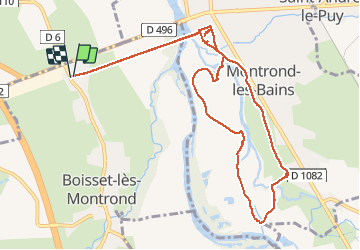
Trail Walking of 11.5 km to be discovered at Auvergne-Rhône-Alpes, Loire, Boisset-lès-Montrond. This trail is proposed by gannet1.
Description
petite marche dans la vallée de la Loire près du chateau féodal de Montrond les Bains.
Testé par le groupe de marche de SELM.
Positioning
Country:
France
Region :
Auvergne-Rhône-Alpes
Department/Province :
Loire
Municipality :
Boisset-lès-Montrond
Location:
Unknown
Start:(Dec)
Start:(UTM)
594110 ; 5054360 (31T) N.
Comments
Trails nearby
![Trail Walking Montrond-les-Bains - Bords de Loire Montrond les bains - Photo](https://media.geolcdn.com/t/375/260/ext.jpg?maxdim=2&url=https%3A%2F%2Fmedia.geolcdn.com%2Ff%2F5be34f98-e604-4240-acdb-03f9603fb3a2.jpg)
![Walking Walking](https://static1.geolcdn.com/sitytour/trail-icons/101.png)
Bords de Loire Montrond les bains
Walking
Medium
Montrond-les-Bains,
Auvergne-Rhône-Alpes,
Loire,
France
![](/images/other/stat-length.png)
18.5 km | 20 km-effort
4h 8min
![](https://static1.geolcdn.com/siteimages/upload/files/16400158638029165_repeat_loop_refresh_sync_direction_icon.png)
Yes
![Trail Mountain bike Montrond-les-Bains - Du Barrage de Villerest au Barrage de Grangent en 10 boucles / Boucle N° 06 : Pont de Montrond-les-Bains (voie verte) - Pont de Rivas - Photo](https://media.geolcdn.com/t/375/260/ext.jpg?maxdim=2&url=https%3A%2F%2Fservices.sitytrail.com%2FGeolivesWS%2FDownloadMedia.ashx%3FTrailID%3D316883%26Media%3D15967_6.jpg)
![Mountain bike Mountain bike](https://static1.geolcdn.com/sitytour/trail-icons/202.png)
Du Barrage de Villerest au Barrage de Grangent en 10 boucles / Boucle N° 06 :...
Mountain bike
Medium
Montrond-les-Bains,
Auvergne-Rhône-Alpes,
Loire,
France
![](/images/other/stat-length.png)
23 km | 25 km-effort
2h 15min
![](https://static1.geolcdn.com/siteimages/upload/files/16400158638029165_repeat_loop_refresh_sync_direction_icon.png)
Yes
![Trail Quad Montrond-les-Bains - randonnée céline et franck st cyr panissiere - Photo](https://media.geolcdn.com/t/375/260/ext.jpg?maxdim=2&url=https%3A%2F%2Fmedia.geolcdn.com%2Ff%2F3a172479-833a-4f17-9e16-1f5dc2c26a56.jpg)
![Quad Quad](https://static1.geolcdn.com/sitytour/trail-icons/404.png)
randonnée céline et franck st cyr panissiere
Quad
Montrond-les-Bains,
Auvergne-Rhône-Alpes,
Loire,
France
![](/images/other/stat-length.png)
124 km | 168 km-effort
6h 49min
![](https://static1.geolcdn.com/siteimages/upload/files/16400158638029165_repeat_loop_refresh_sync_direction_icon.png)
No
![Trail Walking L'Hôpital-le-Grand - L'Hôpital le Grand - Photo](https://media.geolcdn.com/t/375/260/ext.jpg?maxdim=2&url=https%3A%2F%2Fservices.sitytrail.com%2FGeolivesWS%2FDownloadMedia.ashx%3FTrailID%3D161639%26Media%3D20121106150032.jpg)
![Walking Walking](https://static1.geolcdn.com/sitytour/trail-icons/101.png)
L'Hôpital le Grand
Walking
Easy
L'Hôpital-le-Grand,
Auvergne-Rhône-Alpes,
Loire,
France
![](/images/other/stat-length.png)
9.3 km | 9.8 km-effort
2h 12min
![](https://static1.geolcdn.com/siteimages/upload/files/16400158638029165_repeat_loop_refresh_sync_direction_icon.png)
Yes
![Trail Walking Montrond-les-Bains - Ballade Montrond Les Bains - Photo](https://media.geolcdn.com/t/375/260/ext.jpg?maxdim=2&url=https%3A%2F%2Fstatic1.geolcdn.com%2Fsiteimages%2Fupload%2Ffiles%2F1553511878bg_sport_marche.png)
![Walking Walking](https://static1.geolcdn.com/sitytour/trail-icons/101.png)
Ballade Montrond Les Bains
Walking
Medium
Montrond-les-Bains,
Auvergne-Rhône-Alpes,
Loire,
France
![](/images/other/stat-length.png)
9.1 km | 10 km-effort
2h 13min
![](https://static1.geolcdn.com/siteimages/upload/files/16400158638029165_repeat_loop_refresh_sync_direction_icon.png)
Yes
![Trail Walking L'Hôpital-le-Grand - Hôpital le grand - Photo](https://media.geolcdn.com/t/375/260/ext.jpg?maxdim=2&url=https%3A%2F%2Fstatic1.geolcdn.com%2Fsiteimages%2Fupload%2Ffiles%2F1553511878bg_sport_marche.png)
![Walking Walking](https://static1.geolcdn.com/sitytour/trail-icons/101.png)
Hôpital le grand
Walking
Very easy
L'Hôpital-le-Grand,
Auvergne-Rhône-Alpes,
Loire,
France
![](/images/other/stat-length.png)
9.8 km | 10.4 km-effort
2h 32min
![](https://static1.geolcdn.com/siteimages/upload/files/16400158638029165_repeat_loop_refresh_sync_direction_icon.png)
Yes
![Trail Horseback riding Montrond-les-Bains - test - Photo](https://media.geolcdn.com/t/375/260/ext.jpg?maxdim=2&url=https%3A%2F%2Fstatic1.geolcdn.com%2Fsiteimages%2Fupload%2Ffiles%2F1524743154cheval.jpg)
![Horseback riding Horseback riding](https://static1.geolcdn.com/sitytour/trail-icons/301.png)
test
Horseback riding
Very difficult
Montrond-les-Bains,
Auvergne-Rhône-Alpes,
Loire,
France
![](/images/other/stat-length.png)
41 km | 47 km-effort
4h 43min
![](https://static1.geolcdn.com/siteimages/upload/files/16400158638029165_repeat_loop_refresh_sync_direction_icon.png)
No
![Trail Walking Chalain-le-Comtal - chalain le comtal - Photo](https://media.geolcdn.com/t/375/260/ext.jpg?maxdim=2&url=https%3A%2F%2Fstatic1.geolcdn.com%2Fsiteimages%2Fupload%2Ffiles%2F1553511878bg_sport_marche.png)
![Walking Walking](https://static1.geolcdn.com/sitytour/trail-icons/101.png)
chalain le comtal
Walking
Very easy
Chalain-le-Comtal,
Auvergne-Rhône-Alpes,
Loire,
France
![](/images/other/stat-length.png)
9.9 km | 10.9 km-effort
2h 50min
![](https://static1.geolcdn.com/siteimages/upload/files/16400158638029165_repeat_loop_refresh_sync_direction_icon.png)
Yes
![Trail Walking Cuzieu - Cuzieu - Photo](https://media.geolcdn.com/t/375/260/ext.jpg?maxdim=2&url=https%3A%2F%2Fstatic1.geolcdn.com%2Fsiteimages%2Fupload%2Ffiles%2F1553511878bg_sport_marche.png)
![Walking Walking](https://static1.geolcdn.com/sitytour/trail-icons/101.png)
Cuzieu
Walking
Difficult
Cuzieu,
Auvergne-Rhône-Alpes,
Loire,
France
![](/images/other/stat-length.png)
17.1 km | 18.2 km-effort
3h 20min
![](https://static1.geolcdn.com/siteimages/upload/files/16400158638029165_repeat_loop_refresh_sync_direction_icon.png)
Yes