


Rando trail - n°7 Bleu - Col de Pradets

lbuteux
User
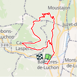

Length
10.2 km

Max alt
1218 m

Uphill gradient
673 m
Km-Effort
19.2 km

Min alt
628 m

Downhill gradient
673 m
Boucle
Yes
Creation date :
2016-07-16 00:00:00.0
Updated on :
2016-07-16 00:00:00.0
--
Difficulty : Unknown

FREE GPS app for hiking
 SityTrail
IGN / Geographical institutes
SityTrail Plus
The world is yours!
About
Trail Other activity of 10.2 km to be discovered at Occitania, Haute-Garonne, Bagnères-de-Luchon. This trail is proposed by lbuteux.
Positioning
Country:
France
Region :
Occitania
Department/Province :
Haute-Garonne
Municipality :
Bagnères-de-Luchon
Location:
Unknown
Start:(Dec)
Start:(UTM)
302822 ; 4740477 (31T) N.
Comments