Trail Walking Saint-Étienne-sur-Usson - St_Etienne_Usson_Suquets - Photo
 jagarnier
jagarnier

User GUIDE

© OpenStreetMap contributors
Length
Length
11.8 km
Max alt
Max alt
832 m
Uphill gradient
Uphill gradient
315 m
Km-Effort
Km-Effort  
16 km
Min alt
Min alt
657 m
Downhill gradient
Downhill gradient
315 m
Boucle
Boucle
Yes
Creation date :
2016-07-22 00:00:00.0
Updated on :
2021-10-26 05:28:33.553

(0 Reviews)

Walking
Walking
3h27
Difficulty : Medium

Scan this QR Code to open this trail in the SityTrail application

FREE GPS app for hiking

Logo SityTrail SityTrail

IGN / Geographical institutes

Download SityTrail from the App Store Download SityTrail from Google Play

Logo SityTrail SityTrail World

The world is yours!

Download SityTrail from the App Store Download SityTrail from Google Play Download SityTrail on Huawei AppGallery

About

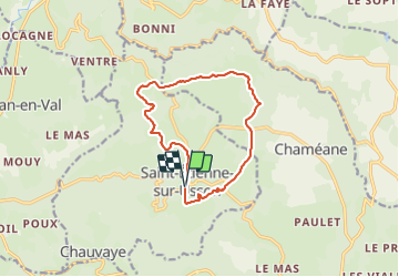
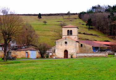
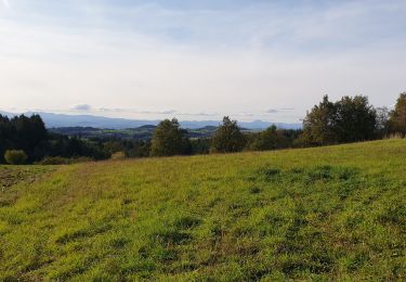
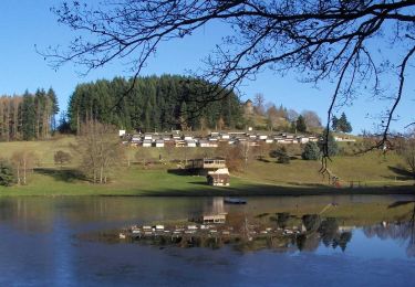
Trail Walking of 11.8 km to be discovered at Auvergne-Rhône-Alpes, Puy-de-Dôme, Saint-Étienne-sur-Usson. This trail is proposed by jagarnier.

Description

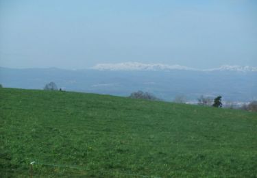
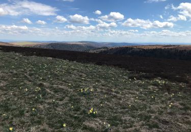
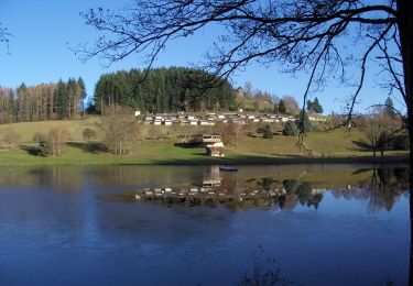
Cette randonnée offre de belles vues panoramiques sur les monts du Forez, Thiers, la vallée de la Dore, la Chaîne des Puys, le Sancy, le château de Mauzun et les villages alentours.

Elevation profile

Photos

Positioning

Country:
France
Region :
Auvergne-Rhône-Alpes
Department/Province :
Puy-de-Dôme
Municipality :
Saint-Étienne-sur-Usson
Location:
Unknown
Start:(UTM)
532200 ; 5039112 (31T) N.

Trails nearby

Trail Walking Saint-Étienne-sur-Usson - Autour de Saint Etienne sur Usson - Photo
Walking
tracegps

Walking

Difficult
(2)
Saint-Étienne-sur-Usson, Auvergne-Rhône-Alpes, Puy-de-Dôme, France
22 km | 32 km-effort
6h 30min
Yes
Trail On foot Saint-Étienne-sur-Usson - La Ronde des Suquets - Photo
On foot
PRO

On foot

Easy
Saint-Étienne-sur-Usson, Auvergne-Rhône-Alpes, Puy-de-Dôme, France
11.9 km | 16.2 km-effort
3h 40min
Yes
Trail On foot Le Vernet-Chaméane - Le Moulin-de-la-Rode - Photo
On foot
PRO

On foot

Easy
Le Vernet-Chaméane, Auvergne-Rhône-Alpes, Puy-de-Dôme, France
11.5 km | 16.1 km-effort
3h 39min
Yes
Trail Walking Le Vernet-Chaméane - Vernet_Varenne_Rode - Photo
Walking
GUIDE
jagarnier

Walking

Medium
(1)
Le Vernet-Chaméane, Auvergne-Rhône-Alpes, Puy-de-Dôme, France
11.3 km | 16 km-effort
3h 15min
Yes
Trail Walking Saint-Jean-en-Val - St_Jean_Val_Hameaux - Photo
Walking
GUIDE
jagarnier

Walking

Medium
Saint-Jean-en-Val, Auvergne-Rhône-Alpes, Puy-de-Dôme, France
10 km | 14.6 km-effort
3h 0min
Yes
Trail Equestrian Le Vernet-Chaméane - J6 - Vernet - ST Gervazy via Champagnat et Esteil - Photo
Equestrian
Maestria

Equestrian

Very easy
(2)
Le Vernet-Chaméane, Auvergne-Rhône-Alpes, Puy-de-Dôme, France
35 km | 45 km-effort
5h 28min
No
Trail On foot La Chapelle-sur-Usson - Perrier - Photo
On foot
PRO

On foot

Easy
La Chapelle-sur-Usson, Auvergne-Rhône-Alpes, Puy-de-Dôme, France
5.5 km | 7.8 km-effort
1h 46min
Yes
Trail Walking Le Vernet-Chaméane - Vernet-La-Varenne_T - Photo
Walking
force

Walking

Easy
Le Vernet-Chaméane, Auvergne-Rhône-Alpes, Puy-de-Dôme, France
11.6 km | 16.3 km-effort
3h 17min
Yes
Trail Walking Le Vernet-Chaméane - Vernet_Varenne_Crepe - Photo
Walking
GUIDE
jagarnier

Walking

Easy
Le Vernet-Chaméane, Auvergne-Rhône-Alpes, Puy-de-Dôme, France
8.1 km | 10.9 km-effort
2h 30min
Yes


Close
My subscriptions