


St_Jacques_Chazotte

jagarnier
User GUIDE

Length
12.4 km

Max alt
740 m

Uphill gradient
332 m
Km-Effort
16.8 km

Min alt
514 m

Downhill gradient
332 m
Boucle
Yes
Creation date :
2016-07-21 00:00:00.0
Updated on :
2024-11-21 12:04:11.361
3h45
Difficulty : Medium

FREE GPS app for hiking
 SityTrail
IGN / Geographical institutes
SityTrail Plus
The world is yours!
About
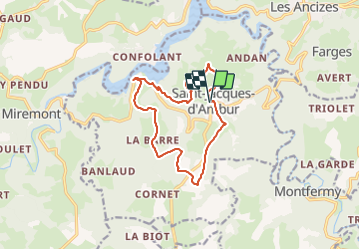
Trail Walking of 12.4 km to be discovered at Auvergne-Rhône-Alpes, Puy-de-Dôme. This trail is proposed by jagarnier.
Photos

Positioning
Country:
France
Region :
Auvergne-Rhône-Alpes
Department/Province :
Puy-de-Dôme
Municipality :
Unknown
Location:
Unknown
Start:(Dec)
Start:(UTM)
482626 ; 5083186 (31T) N.
Comments