


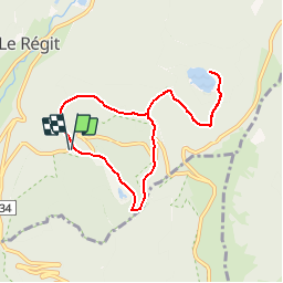
Machey-Tourbières de Machais-Col de l'Etang-Lac Blancheur-Chemin du Génie

patrickbeyrath
User

Length
7.7 km

Max alt
1139 m

Uphill gradient
314 m
Km-Effort
11.9 km

Min alt
974 m

Downhill gradient
314 m
Boucle
Yes
Creation date :
2018-10-13 05:52:24.226
Updated on :
2018-10-13 05:52:24.232
2h39
Difficulty : Medium

FREE GPS app for hiking
 SityTrail
IGN / Geographical institutes
SityTrail Plus
The world is yours!
About
Trail Walking of 7.7 km to be discovered at Grand Est, Vosges, La Bresse. This trail is proposed by patrickbeyrath.
Positioning
Country:
France
Region :
Grand Est
Department/Province :
Vosges
Municipality :
La Bresse
Location:
Unknown
Start:(Dec)
Start:(UTM)
347588 ; 5319438 (32U) N.
Comments