


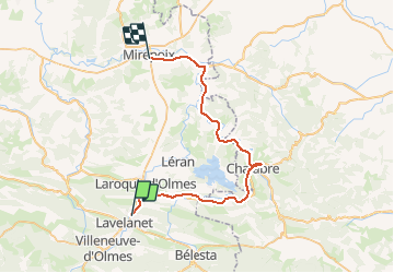
Voie verte LAVELANET MIREPOIX

samterrasse
User

Length
42 km

Max alt
521 m

Uphill gradient
370 m
Km-Effort
47 km

Min alt
304 m

Downhill gradient
571 m
Boucle
No
Creation date :
2016-07-25 00:00:00.0
Updated on :
2016-07-25 00:00:00.0
3h04
Difficulty : Easy

FREE GPS app for hiking
 SityTrail
IGN / Geographical institutes
SityTrail Plus
The world is yours!
About
Trail Mountain bike of 42 km to be discovered at Occitania, Ariège, Lavelanet. This trail is proposed by samterrasse.
Description
Voie verte Lavelanet/Mirepoix en Vélo Tout Chemin
Positioning
Country:
France
Region :
Occitania
Department/Province :
Ariège
Municipality :
Lavelanet
Location:
Unknown
Start:(Dec)
Start:(UTM)
406521 ; 4754767 (31T) N.
Comments
très utile et juste