


castellar-col du berceau

XavierFaidix
User
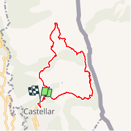

Length
10.1 km

Max alt
1094 m

Uphill gradient
797 m
Km-Effort
21 km

Min alt
334 m

Downhill gradient
794 m
Boucle
Yes
Creation date :
2019-04-01 20:34:40.218
Updated on :
2019-04-01 20:34:40.298
4h01
Difficulty : Difficult

FREE GPS app for hiking
 SityTrail
IGN / Geographical institutes
SityTrail Plus
The world is yours!
About
Trail Walking of 10.1 km to be discovered at Provence-Alpes-Côte d'Azur, Maritime Alps, Castellar. This trail is proposed by XavierFaidix.
Positioning
Country:
France
Region :
Provence-Alpes-Côte d'Azur
Department/Province :
Maritime Alps
Municipality :
Castellar
Location:
Unknown
Start:(Dec)
Start:(UTM)
379124 ; 4851430 (32T) N.
Comments