


Retournemer-Col de Malakoff-Col des Harengs Marinés-Col de la Brande-Abiri Roche Boulardet retour par la Vologne

patrickbeyrath
User
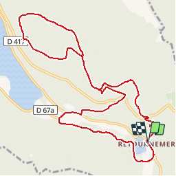

Length
12 km

Max alt
1098 m

Uphill gradient
607 m
Km-Effort
20 km

Min alt
738 m

Downhill gradient
609 m
Boucle
Yes
Creation date :
2018-10-13 05:52:24.037
Updated on :
2018-10-13 05:52:24.047
4h10
Difficulty : Unknown

FREE GPS app for hiking
 SityTrail
IGN / Geographical institutes
SityTrail Plus
The world is yours!
About
Trail Walking of 12 km to be discovered at Grand Est, Vosges, Xonrupt-Longemer. This trail is proposed by patrickbeyrath.
Positioning
Country:
France
Region :
Grand Est
Department/Province :
Vosges
Municipality :
Xonrupt-Longemer
Location:
Unknown
Start:(Dec)
Start:(UTM)
349920 ; 5324682 (32U) N.
Comments