


Puy st Vincent - beal des pres

mhetpierre
User
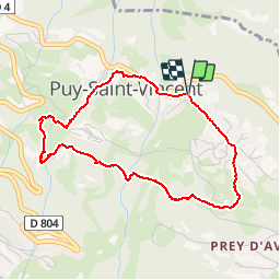

Length
4 km

Max alt
1525 m

Uphill gradient
150 m
Km-Effort
6 km

Min alt
1380 m

Downhill gradient
152 m
Boucle
Yes
Creation date :
2018-08-18 15:30:02.684
Updated on :
2018-08-18 15:30:02.684
1h19
Difficulty : Easy

FREE GPS app for hiking
 SityTrail
IGN / Geographical institutes
SityTrail Plus
The world is yours!
About
Trail Walking of 4 km to be discovered at Provence-Alpes-Côte d'Azur, Hautes-Alpes, Puy-Saint-Vincent. This trail is proposed by mhetpierre.
Positioning
Country:
France
Region :
Provence-Alpes-Côte d'Azur
Department/Province :
Hautes-Alpes
Municipality :
Puy-Saint-Vincent
Location:
Unknown
Start:(Dec)
Start:(UTM)
302180 ; 4966835 (32T) N.
Comments