


Cervieres Mur des Aittes

mhetpierre
User
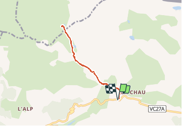

Length
6.9 km

Max alt
2314 m

Uphill gradient
417 m
Km-Effort
12.4 km

Min alt
1892 m

Downhill gradient
418 m
Boucle
Yes
Creation date :
2018-08-18 15:30:02.01
Updated on :
2018-08-18 15:30:02.01
2h47
Difficulty : Medium

FREE GPS app for hiking
 SityTrail
IGN / Geographical institutes
SityTrail Plus
The world is yours!
About
Trail Walking of 6.9 km to be discovered at Provence-Alpes-Côte d'Azur, Hautes-Alpes, Cervières. This trail is proposed by mhetpierre.
Positioning
Country:
France
Region :
Provence-Alpes-Côte d'Azur
Department/Province :
Hautes-Alpes
Municipality :
Cervières
Location:
Unknown
Start:(Dec)
Start:(UTM)
321963 ; 4971896 (32T) N.
Comments