


ND rouvière Hommemort Bonperrier 16kms 761m

guiller
User
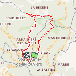

Length
16.1 km

Max alt
932 m

Uphill gradient
643 m
Km-Effort
25 km

Min alt
359 m

Downhill gradient
650 m
Boucle
Yes
Creation date :
2016-07-30 00:00:00.0
Updated on :
2016-07-30 00:00:00.0
5h00
Difficulty : Medium

FREE GPS app for hiking
 SityTrail
IGN / Geographical institutes
SityTrail Plus
The world is yours!
About
Trail Walking of 16.1 km to be discovered at Occitania, Gard, Val-d'Aigoual. This trail is proposed by guiller.
Positioning
Country:
France
Region :
Occitania
Department/Province :
Gard
Municipality :
Val-d'Aigoual
Location:
Notre-Dame-de-la-Rouvière
Start:(Dec)
Start:(UTM)
556154 ; 4877600 (31T) N.
Comments