


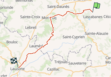
Compostelle 2: 7-Lescabanes - Lauzerte

prv
User

Length
24 km

Max alt
283 m

Uphill gradient
484 m
Km-Effort
31 km

Min alt
127 m

Downhill gradient
520 m
Boucle
No
Creation date :
2016-07-31 00:00:00.0
Updated on :
2016-07-31 00:00:00.0
5h46
Difficulty : Unknown

FREE GPS app for hiking
 SityTrail
IGN / Geographical institutes
SityTrail Plus
The world is yours!
About
Trail Walking of 24 km to be discovered at Occitania, Lot, Lendou-en-Quercy. This trail is proposed by prv.
Description
St Jacques de Compostelle par la vallée du Célé
Positioning
Country:
France
Region :
Occitania
Department/Province :
Lot
Municipality :
Lendou-en-Quercy
Location:
Unknown
Start:(Dec)
Start:(UTM)
364978 ; 4911800 (31T) N.
Comments