Puy st Vincent - vallon de Narreyroux

mhetpierre
User
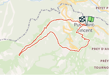

Length
10.5 km

Max alt
1866 m

Uphill gradient
526 m
Km-Effort
17.5 km

Min alt
1381 m

Downhill gradient
526 m
Boucle
Yes
Creation date :
2018-08-18 15:30:01.785
Updated on :
2018-08-18 15:30:01.785
3h41
Difficulty : Medium

FREE GPS app for hiking
 SityTrail
IGN / Geographical institutes
SityTrail Plus
The world is yours!
About
Trail Walking of 10.5 km to be discovered at Provence-Alpes-Côte d'Azur, Hautes-Alpes, Puy-Saint-Vincent. This trail is proposed by mhetpierre.
Positioning
Country:
France
Region :
Provence-Alpes-Côte d'Azur
Department/Province :
Hautes-Alpes
Municipality :
Puy-Saint-Vincent
Location:
Unknown
Start:(Dec)
Start:(UTM)
301895 ; 4966958 (32T) N.
Comments