


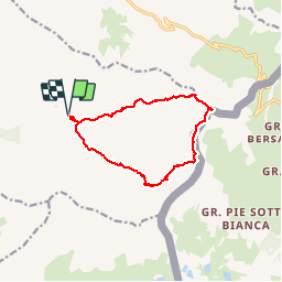
RA 2016 Queyras Pic Caramantran

dfluzin
User

Length
12.4 km

Max alt
3007 m

Uphill gradient
797 m
Km-Effort
23 km

Min alt
2297 m

Downhill gradient
796 m
Boucle
Yes
Creation date :
2016-08-04 00:00:00.0
Updated on :
2016-08-04 00:00:00.0
5h06
Difficulty : Difficult

FREE GPS app for hiking
 SityTrail
IGN / Geographical institutes
SityTrail Plus
The world is yours!
About
Trail Walking of 12.4 km to be discovered at Provence-Alpes-Côte d'Azur, Hautes-Alpes, Saint-Véran. This trail is proposed by dfluzin.
Positioning
Country:
France
Region :
Provence-Alpes-Côte d'Azur
Department/Province :
Hautes-Alpes
Municipality :
Saint-Véran
Location:
Unknown
Start:(Dec)
Start:(UTM)
335061 ; 4949167 (32T) N.
Comments