


ferrals le bois minerve

F.Rioland
User
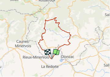

Length
57 km

Max alt
611 m

Uphill gradient
972 m
Km-Effort
70 km

Min alt
69 m

Downhill gradient
973 m
Boucle
Yes
Creation date :
2016-08-07 00:00:00.0
Updated on :
2016-08-07 00:00:00.0
4h19
Difficulty : Unknown

FREE GPS app for hiking
 SityTrail
IGN / Geographical institutes
SityTrail Plus
The world is yours!
About
Trail Cycle of 57 km to be discovered at Occitania, Aude, Azille. This trail is proposed by F.Rioland.
Photos


Positioning
Country:
France
Region :
Occitania
Department/Province :
Aude
Municipality :
Azille
Location:
Unknown
Start:(Dec)
Start:(UTM)
472497 ; 4791658 (31T) N.
Comments
