


ste agnes - cime de baudon - col de gorbio

XavierFaidix
User
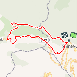

Length
10.4 km

Max alt
1231 m

Uphill gradient
697 m
Km-Effort
19.7 km

Min alt
597 m

Downhill gradient
696 m
Boucle
Yes
Creation date :
2019-04-01 20:34:39.742
Updated on :
2019-04-01 20:34:39.838
4h53
Difficulty : Medium

FREE GPS app for hiking
 SityTrail
IGN / Geographical institutes
SityTrail Plus
The world is yours!
About
Trail Walking of 10.4 km to be discovered at Provence-Alpes-Côte d'Azur, Maritime Alps, Sainte-Agnès. This trail is proposed by XavierFaidix.
Positioning
Country:
France
Region :
Provence-Alpes-Côte d'Azur
Department/Province :
Maritime Alps
Municipality :
Sainte-Agnès
Location:
Unknown
Start:(Dec)
Start:(UTM)
375999 ; 4851072 (32T) N.
Comments