


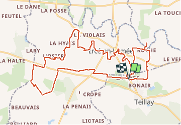
07.08.2016 - ERCE en LAMEE (nouveau)

babeth35
User

Length
27 km

Max alt
107 m

Uphill gradient
346 m
Km-Effort
32 km

Min alt
29 m

Downhill gradient
346 m
Boucle
Yes
Creation date :
2016-08-07 00:00:00.0
Updated on :
2020-07-20 15:29:57.617
7h01
Difficulty : Medium

FREE GPS app for hiking
 SityTrail
IGN / Geographical institutes
SityTrail Plus
The world is yours!
About
Trail Walking of 27 km to be discovered at Brittany, Ille-et-Vilaine, Teillay. This trail is proposed by babeth35.
Positioning
Country:
France
Region :
Brittany
Department/Province :
Ille-et-Vilaine
Municipality :
Teillay
Location:
Unknown
Start:(Dec)
Start:(UTM)
608659 ; 5296990 (30T) N.
Comments