


Autour de Glandage

Fky78
User
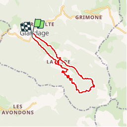

Length
14.5 km

Max alt
1225 m

Uphill gradient
439 m
Km-Effort
20 km

Min alt
856 m

Downhill gradient
441 m
Boucle
Yes
Creation date :
2016-08-09 00:00:00.0
Updated on :
2024-05-31 17:37:43.319
4h37
Difficulty : Very difficult

FREE GPS app for hiking
 SityTrail
IGN / Geographical institutes
SityTrail Plus
The world is yours!
About
Trail Walking of 14.5 km to be discovered at Auvergne-Rhône-Alpes, Drôme, Glandage. This trail is proposed by Fky78.
Description
chemin forestier
Positioning
Country:
France
Region :
Auvergne-Rhône-Alpes
Department/Province :
Drôme
Municipality :
Glandage
Location:
Unknown
Start:(Dec)
Start:(UTM)
705764 ; 4951503 (31T) N.
Comments