Trail Walking Thénisy - Entre Auxence et Voulzie - Photo

Entre Auxence et Voulzie

© OpenStreetMap contributors
Length
Length
21 km
Max alt
Max alt
150 m
Uphill gradient
Uphill gradient
280 m
Km-Effort
Km-Effort  
25 km
Min alt
Min alt
58 m
Downhill gradient
Downhill gradient
280 m
Boucle
Boucle
Yes
Creation date :
2016-08-09 00:00:00.0
Updated on :
2016-08-09 00:00:00.0

(0 Reviews)

Walking
Walking
5h31
Difficulty : Medium

Scan this QR Code to open this trail in the SityTrail application

FREE GPS app for hiking

Logo SityTrail SityTrail

IGN / Geographical institutes

Download SityTrail from the App Store Download SityTrail from Google Play

Logo SityTrail SityTrail World

The world is yours!

Download SityTrail from the App Store Download SityTrail from Google Play Download SityTrail on Huawei AppGallery

About

Trail Walking of 21 km to be discovered at Ile-de-France, Seine-et-Marne, Thénisy. This trail is proposed by pikibangi.

Description

Le Montois, petit pays blotti entre le plateau de Brie et la vallée de la seine, arrosé par l'Auxence, laisse admirer en chemin ses charmants villages et ses vastes points de vue.Jutigny s"étire près de la Voulgie.
Rando agréable

Elevation profile

Positioning

Country:
France
Region :
Ile-de-France
Department/Province :
Seine-et-Marne
Municipality :
Thénisy
Location:
Unknown
Start:(UTM)
512922 ; 5370898 (31U) N.

Trails nearby

Trail Walking Savins - Sognolles en Montois - Photo
Walking
tracegps

Walking

Medium
(1)
Savins, Ile-de-France, Seine-et-Marne, France
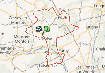
16.2 km | 19.3 km-effort
4h 30min
Yes
Trail On foot Donnemarie-Dontilly - Montereau - Donnemarie Dontilly Linéaire 30 km - Photo
On foot
chessyca

On foot

Difficult
Donnemarie-Dontilly, Ile-de-France, Seine-et-Marne, France
31 km | 38 km-effort
8h 31min
No
Trail Walking Donnemarie-Dontilly - Boucle autour de Donnemarie Dontilly  - Photo
Walking
BrunoMounier

Walking

Difficult
Donnemarie-Dontilly, Ile-de-France, Seine-et-Marne, France
11.4 km | 14.1 km-effort
2h 9min
Yes
Trail Walking Saint-Loup-de-Naud - Églises médiévales au sud de Provins. - Photo
Walking
pikibangi

Walking

Very difficult
Saint-Loup-de-Naud, Ile-de-France, Seine-et-Marne, France
19.6 km | 24 km-effort
4h 50min
Yes
Trail Walking Savins - 180424 EnCours - Photo
Walking
MarcheEtReve

Walking

Very easy
Savins, Ile-de-France, Seine-et-Marne, France
16.7 km | 19.8 km-effort
5h 0min
Yes
Trail Walking Savins - SVG 180424 - Photo
Walking
MarcheEtReve

Walking

Very easy
Savins, Ile-de-France, Seine-et-Marne, France
15.4 km | 18.3 km-effort
5h 37min
No
Trail Walking Mons-en-Montois - Mons en montois 77 - Photo
Walking
raypat

Walking

Very easy
Mons-en-Montois, Ile-de-France, Seine-et-Marne, France
21 km | 25 km-effort
5h 14min
Yes
Trail Other activity Savins - PREPA Montois - Photo
Other activity
MarcheEtReve

Other activity

Very easy
Savins, Ile-de-France, Seine-et-Marne, France
15.8 km | 18.8 km-effort
10min
Yes
Trail Walking Donnemarie-Dontilly - DD4-9-2013 - Photo
Walking
Gessay

Walking

Very easy
Donnemarie-Dontilly, Ile-de-France, Seine-et-Marne, France
4.9 km | 6.2 km-effort
1h 5min
Yes


Close
My subscriptions