


adeps Rosée 2016

vlentma
User
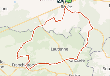

Length
20 km

Max alt
320 m

Uphill gradient
313 m
Km-Effort
24 km

Min alt
204 m

Downhill gradient
313 m
Boucle
Yes
Creation date :
2016-08-11 00:00:00.0
Updated on :
2016-08-11 00:00:00.0
3h04
Difficulty : Unknown

FREE GPS app for hiking
 SityTrail
IGN / Geographical institutes
SityTrail Plus
The world is yours!
About
Trail Walking of 20 km to be discovered at Wallonia, Namur, Florennes. This trail is proposed by vlentma.
Positioning
Country:
Belgium
Region :
Wallonia
Department/Province :
Namur
Municipality :
Florennes
Location:
Rosée
Start:(Dec)
Start:(UTM)
620226 ; 5565797 (31U) N.
Comments