


sortie vtt du 14082016

fabwin
User GUIDE
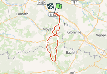

Length
46 km

Max alt
354 m

Uphill gradient
498 m
Km-Effort
53 km

Min alt
239 m

Downhill gradient
499 m
Boucle
Yes
Creation date :
2016-08-18 00:00:00.0
Updated on :
2016-08-18 00:00:00.0
3h28
Difficulty : Medium

FREE GPS app for hiking
 SityTrail
IGN / Geographical institutes
SityTrail Plus
The world is yours!
About
Trail Mountain bike of 46 km to be discovered at Grand Est, Meurthe-et-Moselle, Saint-Clément. This trail is proposed by fabwin.
Description
xafeviller
Positioning
Country:
France
Region :
Grand Est
Department/Province :
Meurthe-et-Moselle
Municipality :
Saint-Clément
Location:
Unknown
Start:(Dec)
Start:(UTM)
323007 ; 5378513 (32U) N.
Comments