Trail Walking Hienghène - Bas Couna  - Photo
 zazie
zazie

User

© OpenStreetMap contributors
Length
Length
6.9 km
Max alt
Max alt
369 m
Uphill gradient
Uphill gradient
249 m
Km-Effort
Km-Effort  
10.2 km
Min alt
Min alt
200 m
Downhill gradient
Downhill gradient
251 m
Boucle
Boucle
Yes
Creation date :
2016-08-15 00:00:00.0
Updated on :
2016-08-15 00:00:00.0

(0 Reviews)

Walking
Walking
2h51
Difficulty : Medium

Scan this QR Code to open this trail in the SityTrail application

FREE GPS app for hiking

Logo SityTrail SityTrail

IGN / Geographical institutes

Download SityTrail from the App Store Download SityTrail from Google Play

Logo SityTrail SityTrail World

The world is yours!

Download SityTrail from the App Store Download SityTrail from Google Play Download SityTrail on Huawei AppGallery

About

Trail Walking of 6.9 km to be discovered at Unknown, North Province, Hienghène. This trail is proposed by zazie.

Description

balade familiale mais déconseillée aux petits enfants avec retour dans le lit de la rivière

Elevation profile

Positioning

Country:
France
Region :
Unknown
Department/Province :
North Province
Municipality :
Hienghène
Location:
Unknown
Start:(UTM)
477174 ; 7712291 (58K) S.

Trails nearby

Trail Walking Hienghène - 2023-04-14_08h36m52_cascade-de-tao-hienghene - Photo
Walking
toutankhcarton

Walking

Easy
(1)
Hienghène, Unknown, North Province, France
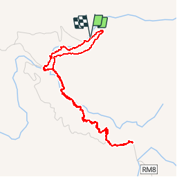
1.9 km | 3.2 km-effort
44min
Yes
Trail Walking Hienghène - Les Roches de la Ouaïème - Hienghène (NC) - Photo
Walking
toutankhcarton

Walking

Medium
Hienghène, Unknown, North Province, France
7.8 km | 17.5 km-effort
3h 27min
Yes
Trail Walking Hienghène - la poule - Photo
Walking
PEGAM

Walking

Very easy
Hienghène, Unknown, North Province, France
7.5 km | 12 km-effort
1h 56min
Yes


Close
My subscriptions