Trail Walking Colombier-le-Vieux - boucieu le roi - rando decouverte - Photo

boucieu le roi - rando decouverte

 bob2023
bob2023

User

© OpenStreetMap contributors
Length
Length
4.2 km
Max alt
Max alt
433 m
Uphill gradient
Uphill gradient
188 m
Km-Effort
Km-Effort  
6.7 km
Min alt
Min alt
251 m
Downhill gradient
Downhill gradient
188 m
Boucle
Boucle
Yes
Creation date :
2018-08-26 08:32:12.057
Updated on :
2018-08-26 08:32:12.077

(1 Reviews)

Walking
Walking
1h30
Difficulty : Easy

Scan this QR Code to open this trail in the SityTrail application

FREE GPS app for hiking

Logo SityTrail SityTrail

IGN / Geographical institutes

Download SityTrail from the App Store Download SityTrail from Google Play

Logo SityTrail SityTrail World

The world is yours!

Download SityTrail from the App Store Download SityTrail from Google Play Download SityTrail on Huawei AppGallery

About

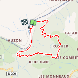
Trail Walking of 4.2 km to be discovered at Auvergne-Rhône-Alpes, Ardèche, Colombier-le-Vieux. This trail is proposed by bob2023.

Description

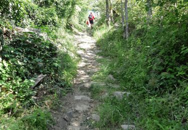
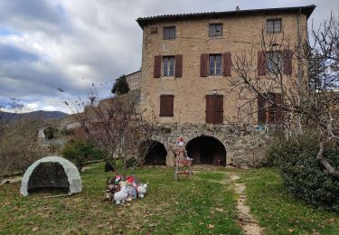
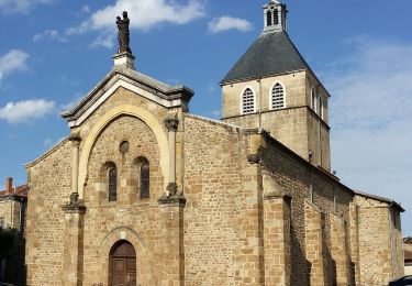
Très jolie petite randonnée dans la campagne Ardèchoise, qui longe la rivière le Doux pour se poursuivre en sous-bois à travers pins et chênes, pour au point culminant offrir une belle vue sur les villages de Boucieu le roi, d'Arlebosc, et de Colombier le vieux. La descente ce fait également en sous bois. Vous serez accompagné en saison par le sifflet du petit train à vapeur de l'Ardèche. Attention au croisement avec la voie ferrée, trains et vélorail.

Elevation profile

Photos

Positioning

Country:
France
Region :
Auvergne-Rhône-Alpes
Department/Province :
Ardèche
Municipality :
Colombier-le-Vieux
Location:
Unknown
Start:(UTM)
633420 ; 4988917 (31T) N.

Comments

Please log in to post a review or rate the element


Trails nearby

Trail sport Boucieu-le-Roi - Boucieu le Roi - Photo
sport
alinetpierre

sport

Very easy
Boucieu-le-Roi, Auvergne-Rhône-Alpes, Ardèche, France
15.4 km | 22 km-effort
Unknown
Yes
Trail On foot Colombier-le-Vieux - Randonnée : Les Gorges de la Daronne - Photo
On foot
PRO

On foot

Medium
Colombier-le-Vieux, Auvergne-Rhône-Alpes, Ardèche, France
14.8 km | 21 km-effort
4h 46min
Yes
Trail On foot Saint-Félicien - Randonnée : Tour du Pays de Saint-Félicien - Photo
On foot
PRO

On foot

Difficult
Saint-Félicien, Auvergne-Rhône-Alpes, Ardèche, France
26 km | 37 km-effort
8h 29min
No
Trail Walking Arlebosc - 07 arlebosc rando organise - Photo
Walking
himba26100

Walking

Medium
Arlebosc, Auvergne-Rhône-Alpes, Ardèche, France
21 km | 29 km-effort
6h 3min
Yes
Trail Walking Colombier-le-Vieux - Gorges Daronne - Photo
Walking
Djac

Walking

Medium
(2)
Colombier-le-Vieux, Auvergne-Rhône-Alpes, Ardèche, France
10.4 km | 16.3 km-effort
3h 32min
Yes
Trail Walking Étables - gorge de la daronne - Photo
Walking
christian4

Walking

Easy
(2)
Étables, Auvergne-Rhône-Alpes, Ardèche, France
8.3 km | 12.9 km-effort
2h 53min
Yes
Trail Walking Boucieu-le-Roi - boucieu le roi  - Photo
Walking
guyzinz

Walking

Very difficult
Boucieu-le-Roi, Auvergne-Rhône-Alpes, Ardèche, France
15.5 km | 22 km-effort
5h 44min
Yes
Trail On foot Bozas - Randonnée : Tour du Pays de Saint-Félicien - Jour 1 - Photo
On foot
PRO

On foot

Medium
Bozas, Auvergne-Rhône-Alpes, Ardèche, France
16.8 km | 26 km-effort
5h 51min
No
Trail Walking Étables - Morens (Étables) - Photo
Walking
crocau

Walking

Medium
Étables, Auvergne-Rhône-Alpes, Ardèche, France
3.8 km | 6.3 km-effort
1h 28min
Yes


Close
My subscriptions