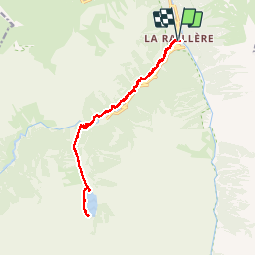
Trail Walking Cauterets - Lac de Gaube - Photo
 Bobol
Bobol

User

© OpenStreetMap contributors
Length
Length
16.3 km
Max alt
Max alt
1777 m
Uphill gradient
Uphill gradient
809 m
Km-Effort
Km-Effort  
27 km
Min alt
Min alt
1043 m
Downhill gradient
Downhill gradient
808 m
Boucle
Boucle
Yes
Creation date :
2016-08-18 00:00:00.0
Updated on :
2016-08-18 00:00:00.0

(0 Reviews)

Walking
Walking
6h56
Difficulty : Difficult

Scan this QR Code to open this trail in the SityTrail application

FREE GPS app for hiking

Logo SityTrail SityTrail

IGN / Geographical institutes

Download SityTrail from the App Store Download SityTrail from Google Play

Logo SityTrail SityTrail Plus

The world is yours!

Download SityTrail from the App Store Download SityTrail from Google Play Download SityTrail on Huawei AppGallery

About

Trail Walking of 16.3 km to be discovered at Occitania, Hautespyrenees, Cauterets. This trail is proposed by Bobol.

Description

Magnifique randonnée qui commence à Pont de Benqués par le chemins des cascades (environ 400m de dénivelé). Arrivé à Pont d'Espagne, prendre le téléphérique ou le chemin (1h15mm de montée) et arrivée au lac de Gaube. Je l'ai marqué "difficile" car le chemin de cascades est pavé de cailloux qui glissent par temps de pluie. Je recommande l'usage de bâtons, surtout pour la descente.

Elevation profile

Positioning

Country:
France
Region :
Occitania
Department/Province :
Hautespyrenees
Municipality :
Cauterets
Location:
Unknown
Start:(UTM)
736096 ; 4750737 (30T) N.


Close
My subscriptions