


Trail Ahuy 19 08 2016

Fab-Oz
User
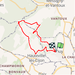

Length
14 km

Max alt
411 m

Uphill gradient
332 m
Km-Effort
18.4 km

Min alt
296 m

Downhill gradient
334 m
Boucle
Yes
Creation date :
2019-05-10 09:07:14.492
Updated on :
2019-05-10 09:07:15.004
1h33
Difficulty : Medium

FREE GPS app for hiking
 SityTrail
IGN / Geographical institutes
SityTrail Plus
The world is yours!
About
Trail Running of 14 km to be discovered at Bourgogne-Franche-Comté, Côte-d'Or, Ahuy. This trail is proposed by Fab-Oz.
Positioning
Country:
France
Region :
Bourgogne-Franche-Comté
Department/Province :
Côte-d'Or
Municipality :
Ahuy
Location:
Unknown
Start:(Dec)
Start:(UTM)
652286 ; 5248231 (31T) N.
Comments