


Tour du Mont myon

Ajax44
User
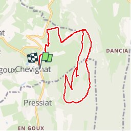

Length
11.7 km

Max alt
657 m

Uphill gradient
479 m
Km-Effort
18.1 km

Min alt
327 m

Downhill gradient
480 m
Boucle
Yes
Creation date :
2016-08-21 00:00:00.0
Updated on :
2016-08-21 00:00:00.0
3h44
Difficulty : Medium

FREE GPS app for hiking
 SityTrail
IGN / Geographical institutes
SityTrail Plus
The world is yours!
About
Trail Walking of 11.7 km to be discovered at Auvergne-Rhône-Alpes, Ain, Courmangoux. This trail is proposed by Ajax44.
Positioning
Country:
France
Region :
Auvergne-Rhône-Alpes
Department/Province :
Ain
Municipality :
Courmangoux
Location:
Unknown
Start:(Dec)
Start:(UTM)
683642 ; 5133574 (31T) N.
Comments