


Forêt de chaux

MathiasGrunenwald
User
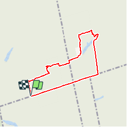

Length
6.6 km

Max alt
262 m

Uphill gradient
61 m
Km-Effort
7.4 km

Min alt
244 m

Downhill gradient
61 m
Boucle
Yes

Signpost
Creation date :
2016-08-23 00:00:00.0
Updated on :
2016-08-23 00:00:00.0
1h52
Difficulty : Easy

FREE GPS app for hiking
 SityTrail
IGN / Geographical institutes
SityTrail Plus
The world is yours!
About
Trail Walking of 6.6 km to be discovered at Bourgogne-Franche-Comté, Jura, Our. This trail is proposed by MathiasGrunenwald.
Description
Repérage


Positioning
Country:
France
Region :
Bourgogne-Franche-Comté
Department/Province :
Jura
Municipality :
Our
Location:
Unknown
Start:(Dec)
Start:(UTM)
701650 ; 5217171 (31T) N.
Comments