


Chemin de Gradille

jpipacific
User

Length
9.7 km

Max alt
295 m

Uphill gradient
167 m
Km-Effort
11.9 km

Min alt
220 m

Downhill gradient
164 m
Boucle
Yes
Creation date :
2016-08-25 00:00:00.0
Updated on :
2016-08-25 00:00:00.0
2h30
Difficulty : Easy

FREE GPS app for hiking
 SityTrail
IGN / Geographical institutes
SityTrail Plus
The world is yours!
About
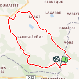
Trail Walking of 9.7 km to be discovered at Occitania, Tarn, Castelnau-de-Montmiral. This trail is proposed by jpipacific.
Description
Rando en sous-bois sur une grande partie du parcours. Pas de position dominante. Quelques points d'e vues furtifs;dommage!
Positioning
Country:
France
Region :
Occitania
Department/Province :
Tarn
Municipality :
Castelnau-de-Montmiral
Location:
Unknown
Start:(Dec)
Start:(UTM)
407455 ; 4864722 (31T) N.
Comments