


Ernonheid

Fiquet2011
User
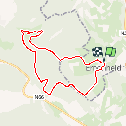

Length
7.8 km

Max alt
375 m

Uphill gradient
185 m
Km-Effort
10.3 km

Min alt
246 m

Downhill gradient
184 m
Boucle
Yes
Creation date :
2016-08-27 00:00:00.0
Updated on :
2016-08-27 00:00:00.0
3h00
Difficulty : Unknown

FREE GPS app for hiking
 SityTrail
IGN / Geographical institutes
SityTrail Plus
The world is yours!
About
Trail Walking of 7.8 km to be discovered at Wallonia, Liège, Aywaille. This trail is proposed by Fiquet2011.
Positioning
Country:
Belgium
Region :
Wallonia
Department/Province :
Liège
Municipality :
Aywaille
Location:
Ernonheid
Start:(Dec)
Start:(UTM)
689464 ; 5586950 (31U) N.
Comments
attention passage dans propriété privé et quelques à travers tout.
Souvent dans des vallées avec vue limitée. Beau château de Grimonster mais ne passe-t-on pas dans une propriété privée ? 2 endroits où il n'y a plus de chemin : vers source ruisseau étang pourri (passage difficile) puis pour rejoindre Taille Boha