


manternach

bohynm
User
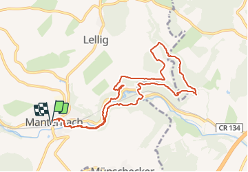

Length
9.9 km

Max alt
287 m

Uphill gradient
256 m
Km-Effort
13.3 km

Min alt
182 m

Downhill gradient
258 m
Boucle
Yes
Creation date :
2016-09-08 00:00:00.0
Updated on :
2016-09-08 00:00:00.0
2h13
Difficulty : Medium

FREE GPS app for hiking
 SityTrail
IGN / Geographical institutes
SityTrail Plus
The world is yours!
About
Trail Walking of 9.9 km to be discovered at Unknown, Canton Grevenmacher, Manternach. This trail is proposed by bohynm.
Positioning
Country:
Luxembourg
Region :
Unknown
Department/Province :
Canton Grevenmacher
Municipality :
Manternach
Location:
Unknown
Start:(Dec)
Start:(UTM)
314260 ; 5509239 (32U) N.
Comments