


CanalduMidi_contournement bagnas

m261212
User
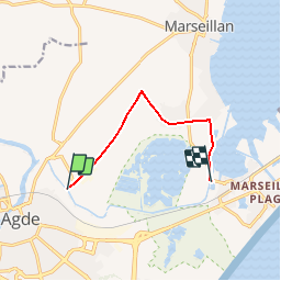

Length
6.9 km

Max alt
18 m

Uphill gradient
43 m
Km-Effort
7.5 km

Min alt
-2 m

Downhill gradient
45 m
Boucle
No
Creation date :
2017-08-26 00:00:00.0
Updated on :
2017-08-26 00:00:00.0
26m
Difficulty : Medium

FREE GPS app for hiking
 SityTrail
IGN / Geographical institutes
SityTrail Plus
The world is yours!
About
Trail Cycle of 6.9 km to be discovered at Occitania, Hérault, Agde. This trail is proposed by m261212.
Positioning
Country:
France
Region :
Occitania
Department/Province :
Hérault
Municipality :
Agde
Location:
Unknown
Start:(Dec)
Start:(UTM)
539475 ; 4796411 (31T) N.
Comments