


Aiguille 2016 09 05

psesjs
User
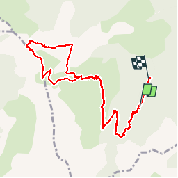

Length
12.5 km

Max alt
2028 m

Uphill gradient
833 m
Km-Effort
24 km

Min alt
1161 m

Downhill gradient
965 m
Boucle
No
Creation date :
2016-09-07 00:00:00.0
Updated on :
2016-09-07 00:00:00.0
6h16
Difficulty : Difficult

FREE GPS app for hiking
 SityTrail
IGN / Geographical institutes
SityTrail Plus
The world is yours!
About
Trail Walking of 12.5 km to be discovered at Auvergne-Rhône-Alpes, Isère, Châtel-en-Trièves. This trail is proposed by psesjs.
Positioning
Country:
France
Region :
Auvergne-Rhône-Alpes
Department/Province :
Isère
Municipality :
Châtel-en-Trièves
Location:
Unknown
Start:(Dec)
Start:(UTM)
725283 ; 4964043 (31T) N.
Comments