


Rieux Plaine des Gaulois

pidjam
User
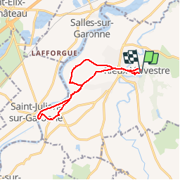

Length
12.8 km

Max alt
271 m

Uphill gradient
179 m
Km-Effort
15.1 km

Min alt
207 m

Downhill gradient
176 m
Boucle
Yes
Creation date :
2016-09-09 00:00:00.0
Updated on :
2016-09-09 00:00:00.0
3h21
Difficulty : Easy

FREE GPS app for hiking
 SityTrail
IGN / Geographical institutes
SityTrail Plus
The world is yours!
About
Trail Other activity of 12.8 km to be discovered at Occitania, Haute-Garonne, Rieux-Volvestre. This trail is proposed by pidjam.
Description
Balade variée à éviter en temps pluvieux (traverse de Beaulieu très pentue);la zone de falaise effondrée à éviter est indiquée (le balisage jaune est juste sauf aux abords du village Gaulois)
Photos


Positioning
Country:
France
Region :
Occitania
Department/Province :
Haute-Garonne
Municipality :
Rieux-Volvestre
Location:
Unknown
Start:(Dec)
Start:(UTM)
354228 ; 4790890 (31T) N.
Comments