


Pont_Chateau_Marinier

jagarnier
User GUIDE
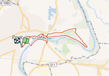

Length
8.2 km

Max alt
358 m

Uphill gradient
96 m
Km-Effort
9.4 km

Min alt
301 m

Downhill gradient
95 m
Boucle
Yes
Creation date :
2016-09-09 00:00:00.0
Updated on :
2024-06-03 13:49:20.484
2h30
Difficulty : Easy

FREE GPS app for hiking
 SityTrail
IGN / Geographical institutes
SityTrail Plus
The world is yours!
About
Trail Walking of 8.2 km to be discovered at Auvergne-Rhône-Alpes, Puy-de-Dôme, Pont-du-Château. This trail is proposed by jagarnier.
Photos

Positioning
Country:
France
Region :
Auvergne-Rhône-Alpes
Department/Province :
Puy-de-Dôme
Municipality :
Pont-du-Château
Location:
Unknown
Start:(Dec)
Start:(UTM)
518946 ; 5071090 (31T) N.
Comments