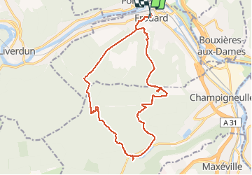
Trail Walking Frouard - Foret de Haye - Photo
© OpenStreetMap contributors
Length
Length
18 km
Max alt
Max alt
364 m
Uphill gradient
Uphill gradient
351 m
Km-Effort
Km-Effort  
23 km
Min alt
Min alt
206 m
Downhill gradient
Downhill gradient
360 m
Boucle
Boucle
Yes
Creation date :
2016-09-11 00:00:00.0
Updated on :
2016-09-11 00:00:00.0

(0 Reviews)

Walking
Walking
4h15
Difficulty : Very easy

Scan this QR Code to open this trail in the SityTrail application

FREE GPS app for hiking

Logo SityTrail SityTrail

IGN / Geographical institutes

Download SityTrail from the App Store Download SityTrail from Google Play

Logo SityTrail SityTrail Plus

The world is yours!

Download SityTrail from the App Store Download SityTrail from Google Play Download SityTrail on Huawei AppGallery

About

Trail Walking of 18 km to be discovered at Grand Est, Meurthe-et-Moselle, Frouard. This trail is proposed by webmammuth.

Description

Balade au départ de Frouard sur le plateau de Haye. Il y a quelques erreurs et quelques errances. Éviter d'aller derrière la station de pompage, au rendez vous du gascon et dans le fort. Pour le reste, c'est ok.. ??

Elevation profile

Photos

Points of interest

Point of interest Frouard - Point 1 - Photo
webmammuth
FROUARD 

Positioning

Country:
France
Region :
Grand Est
Department/Province :
Meurthe-et-Moselle
Municipality :
Frouard
Location:
Unknown
Start:(Dec)
Start:(UTM)
288951 ; 5404755 (32U) N.


Close
My subscriptions