


2016-09-17 Transvolcanique Aller

Lucquiaud
User
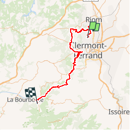

Length
88 km

Max alt
1427 m

Uphill gradient
2300 m
Km-Effort
116 km

Min alt
363 m

Downhill gradient
1633 m
Boucle
No
Creation date :
2018-09-15 15:04:57.651
Updated on :
2018-09-15 15:04:57.665
7h26
Difficulty : Very difficult

FREE GPS app for hiking
 SityTrail
IGN / Geographical institutes
SityTrail Plus
The world is yours!
About
Trail Mountain bike of 88 km to be discovered at Auvergne-Rhône-Alpes, Puy-de-Dôme, Blanzat. This trail is proposed by Lucquiaud.
Positioning
Country:
France
Region :
Auvergne-Rhône-Alpes
Department/Province :
Puy-de-Dôme
Municipality :
Blanzat
Location:
Unknown
Start:(Dec)
Start:(UTM)
506079 ; 5074302 (31T) N.
Comments