


2016-09-18 Transvolcanique Retour

Lucquiaud
User
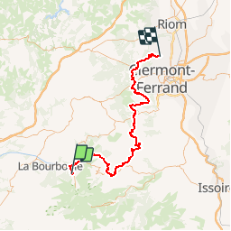

Length
79 km

Max alt
1411 m

Uphill gradient
1840 m
Km-Effort
106 km

Min alt
378 m

Downhill gradient
2512 m
Boucle
No
Creation date :
2018-09-15 15:04:54.574
Updated on :
2018-09-15 15:04:57.262
6h26
Difficulty : Very difficult

FREE GPS app for hiking
 SityTrail
IGN / Geographical institutes
SityTrail Plus
The world is yours!
About
Trail Mountain bike of 79 km to be discovered at Auvergne-Rhône-Alpes, Puy-de-Dôme, Mont-Dore. This trail is proposed by Lucquiaud.
Positioning
Country:
France
Region :
Auvergne-Rhône-Alpes
Department/Province :
Puy-de-Dôme
Municipality :
Mont-Dore
Location:
Unknown
Start:(Dec)
Start:(UTM)
485020 ; 5046560 (31T) N.
Comments