


Luik - Hertogenwald Occidental

misph
User
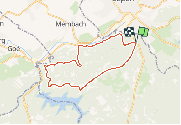

Length
13.3 km

Max alt
387 m

Uphill gradient
273 m
Km-Effort
16.9 km

Min alt
252 m

Downhill gradient
274 m
Boucle
Yes
Creation date :
2017-05-05 00:00:00.0
Updated on :
2017-05-05 00:00:00.0
3h38
Difficulty : Medium

FREE GPS app for hiking
 SityTrail
IGN / Geographical institutes
SityTrail Plus
The world is yours!
About
Trail Other activity of 13.3 km to be discovered at Wallonia, Liège, Baelen. This trail is proposed by misph.
Description
Auteur: RVD 2016.
NNO meer van Gileppe.
Luik - Hertogenwald Occidental


Positioning
Country:
Belgium
Region :
Wallonia
Department/Province :
Liège
Municipality :
Baelen
Location:
Membach
Start:(Dec)
Start:(UTM)
290608 ; 5610735 (32U) N.
Comments