


Ceton 16

togolo28
User
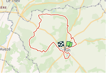

Length
16.5 km

Max alt
202 m

Uphill gradient
293 m
Km-Effort
20 km

Min alt
100 m

Downhill gradient
292 m
Boucle
Yes
Creation date :
2017-12-19 00:00:00.0
Updated on :
2019-01-05 14:59:37.351
3h30
Difficulty : Medium

FREE GPS app for hiking
 SityTrail
IGN / Geographical institutes
SityTrail Plus
The world is yours!
About
Trail Walking of 16.5 km to be discovered at Normandy, Orne, Ceton. This trail is proposed by togolo28.
Positioning
Country:
France
Region :
Normandy
Department/Province :
Orne
Municipality :
Ceton
Location:
Unknown
Start:(Dec)
Start:(UTM)
332823 ; 5343742 (31U) N.
Comments