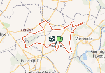
7.8 km | 9.2 km-effort
Chambry Grand Parcours
CC.RIDER
User
Length
18.3 km
Max alt
129 m
Uphill gradient
160 m
Km-Effort
20 km
Min alt
83 m
Downhill gradient
161 m
Boucle
Yes
Creation date :
2016-09-21 00:00:00.0
Updated on :
2016-09-21 00:00:00.0
4h29
Difficulty : Easy
FREE GPS app for hiking
About
Trail Walking of 18.3 km to be discovered at Ile-de-France, Seine-et-Marne, Chambry. This trail is proposed by CC.RIDER.
Description
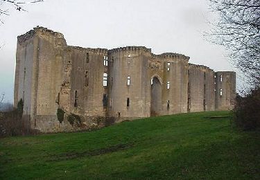
Au point de départ de la bataille de la Marne (1914)
Positioning
Country:
France
Region :
Ile-de-France
Department/Province :
Seine-et-Marne
Municipality :
Chambry
Location:
Unknown
Start:(Dec)
Start:(UTM)
492195 ; 5427301 (31U) N.
Comments
Trails nearby
SM_CREGY-LES-MEAUX_8Km
Walking
Medium
(7)
Crégy-lès-Meaux,
Ile-de-France,
Seine-et-Marne,
France
2h 5min
Yes
MR_MONTHYON_5.4Km
Walking
Medium
(1)
Monthyon,
Ile-de-France,
Seine-et-Marne,
France
5.4 km | 6.4 km-effort
1h 24min
Yes
Etrepilly Grand parcours
Walking
Easy
(1)
Étrépilly,
Ile-de-France,
Seine-et-Marne,
France
19.3 km | 22 km-effort
5h 0min
Yes
Le tour du Grand Paris via le GR1 - Etape 10 Meaux Mortcerf
Walking
Difficult
Meaux,
Ile-de-France,
Seine-et-Marne,
France
34 km | 40 km-effort
6h 35min
No
MEAUX BOUCLE 19 KM
Walking
Very easy
(1)
Meaux,
Ile-de-France,
Seine-et-Marne,
France
19.1 km | 22 km-effort
4h 47min
Yes
Trail court - Chauconin 77124
Running
Difficult
(1)
,
Ile-de-France,
Seine-et-Marne,
France
21 km | 26 km-effort
2h 1min
Yes
Canal de l'Ourq juillet 2015
Mountain bike
Medium
Varreddes,
Ile-de-France,
Seine-et-Marne,
France
85 km | 94 km-effort
6h 13min
Yes
Meaux Nanteuil Mareuil
Running
Medium
(1)
Meaux,
Ile-de-France,
Seine-et-Marne,
France
11.8 km | 13.8 km-effort
1h 0min
Yes
Trilport
Walking
Easy
(1)
Trilport,
Ile-de-France,
Seine-et-Marne,
France
19.5 km | 21 km-effort
4h 42min
Yes